The Northern Picket Ski Traverse
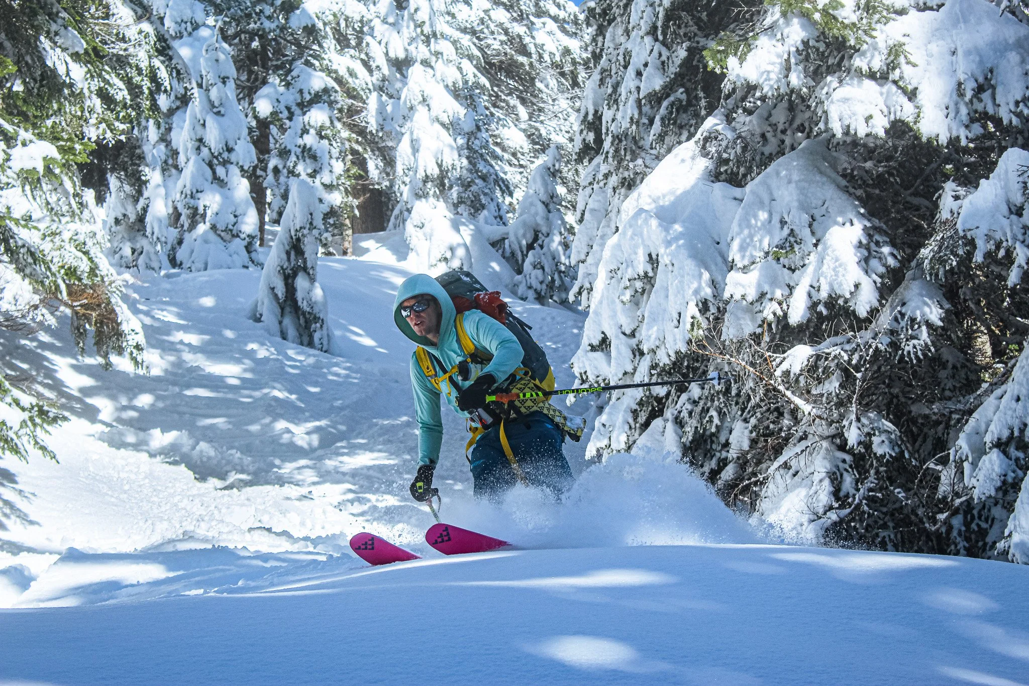
JT finding the best way down. Mt. Challenger watching over
The Pickets are hard to describe. It’s one of the most magnificent and remote mountain ranges in the lower 48, and is still relatively “unknown”. From Lowell Skoog’s first traverse of the entire range in May of 1985, to Wayne Wallace’s solo ascent of Mt. Fury’s Mondo Ridge, these mountains hold a mythical place in the local climbing and skiing community. But outside of that, the name “Pickets” only bring images of white fences in a suburb. I was born and raised in Washington, camping and resort skiing. I had no idea what the Pickets were until I was told in 5 months I was going to be traversing miles across them.
Overview
Location: The Picket Range, North Cascades, Washington
Route: Hannegan Pass Trailhead to Ross Lake Dam
Dates: April 28 - May 4, 2022
Team: 9 total. JT, Trask, other crazy individuals
Gear: Ski traverse gear, glacier gear, food and fuel for 7 days
Background:
After a couple years of absence from the Pacific Northwest while stationed over on the east coast, I returned to Washington in the Fall of 2021. I soon got assigned to a new unit and was told I was going to be on a specialty mountain team. I didn’t realize what exactly that meant at the time, or what all that would entail, but I couldn’t be more psyched. I loved the mountains.
After meeting everyone on the team, I got a run down of what was in store for the next couple months. We would be training up to do a multi day ski traverse across the Picket Range. Excited to get to travel to a new country or state, I soon learned that the Picket’s are right at home in Washington. The more I learned, the more I thought “how the hell have I never heard of this place before?” There is a reason the Enchantments see hoards of people every year, but a fraction of the people have been in the shadow of Mt. Fury.
Being a little naive at the time, it sounded like a great adventure. Sure, half the team had learned to ski in the past year, and only a few had ever done a multi-day traverse. But we were tough, confident, and optimistic, probably a little more than we should have been. But we were willing to put in the work. The next several months involved overnight ski camping, slogs up to Camp Muir, rescue and crevasse training, and most importantly, learning how to move as a team. It’s not often you see more than groups of 4 to 5 in the backcountry, but 9? Going through one of the least accessible chunks of land in the lower 48?
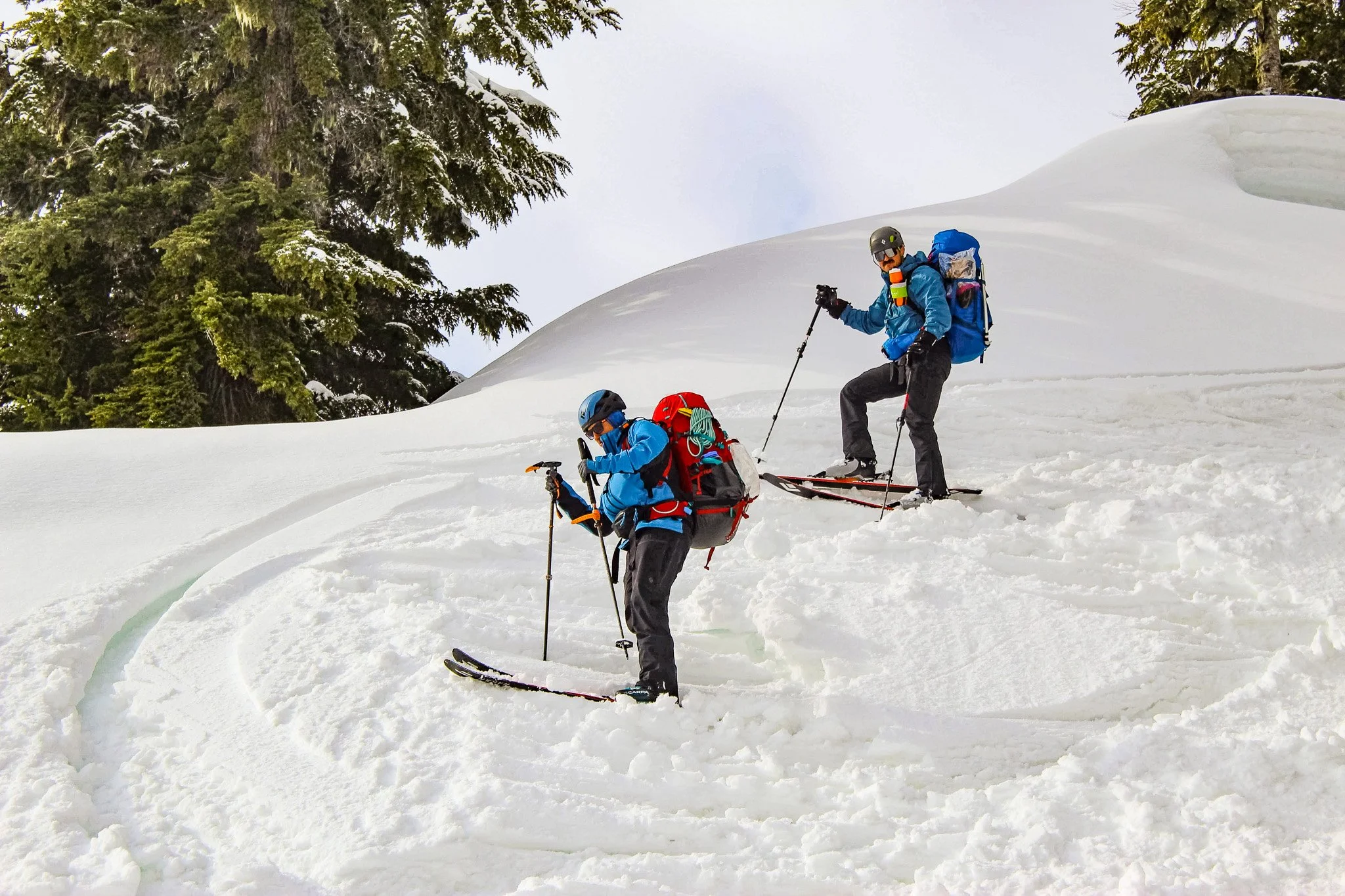
Enjoying a nice weekday “work” day training for the Pickets at Snoqualmie Pass.
The Route:
Day 1
The first day was relatively simple, going from the Hannegan Trailhead to camp at Hannegan Pass. Putting the skins on, gearing up, and making final preparations really let reality sink in on the gravity of what we were about to embark on. Those first few steps you take, knowing you will be making tens of thousands more, is a feeling that I still can’t get used to.
We walked for a mile or so before being able to start skinning. 2022 was a great snow year. Cold temps low down, and a mid April snowstorm left a hefty snowpack that would lead to great skiing through July. However, this also meant a pro-longed spring avalanche cycle, as the the winter snow warms up and sheds, until it eventually compacts and stabilizes enough to provide safer travel. Although we were enjoying the benefits of having plenty of snow covering any obstacles as we made our way up to the pass, the downsides of this would come to bite us later.
Getting up to the pass, we set up camp on a slightly overcast evening. Although the day was relatively simple, a few thousand feet of elevation gain with the heaviest packs we had all trip still made for tired legs.
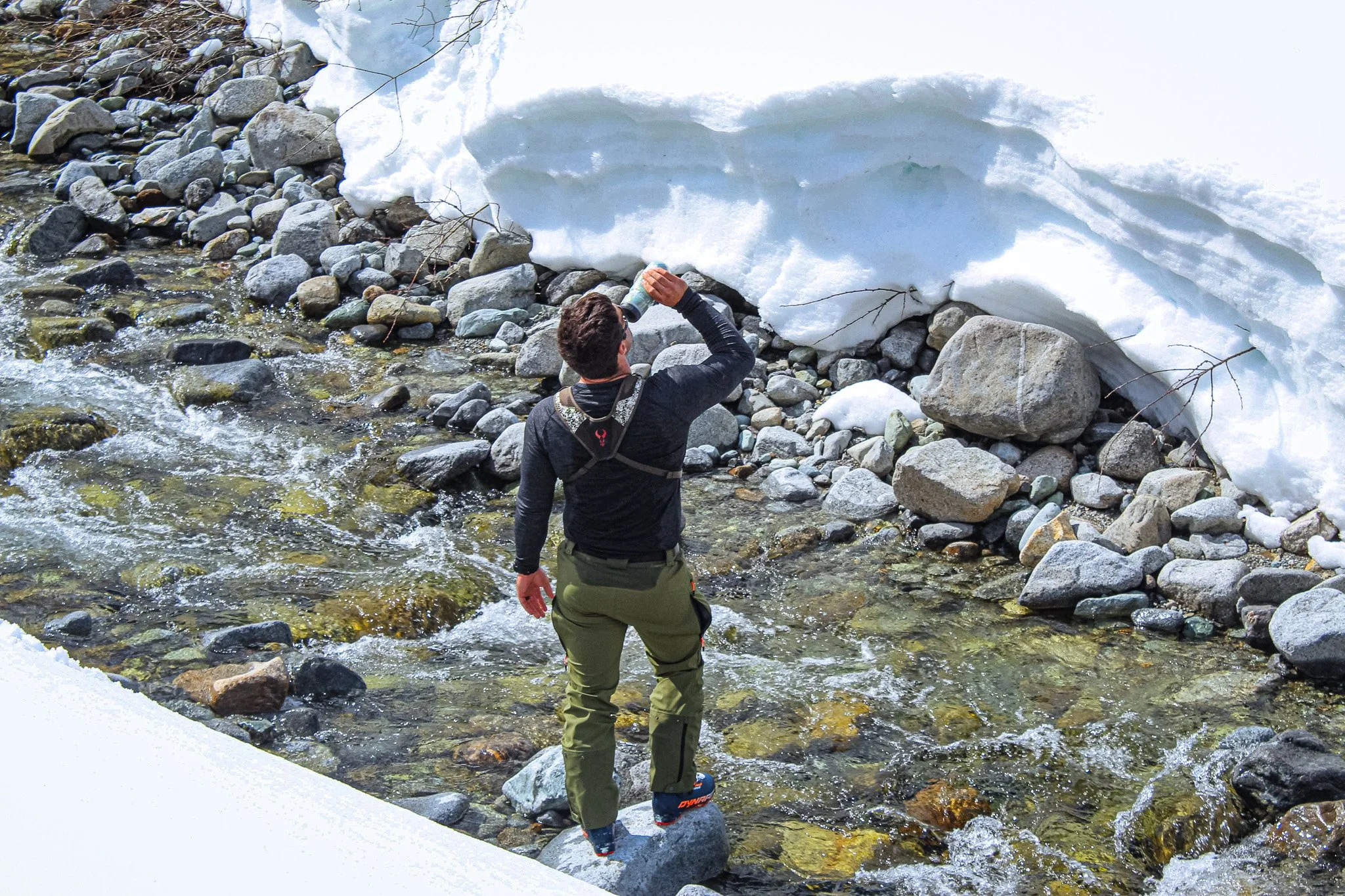
Filling up from the river on day one as we made our way up to Hannegan Pass
Day 2:
Another “simple” day looking at the topographic map. We were all downhill on this day, making our way to the base of Easy Ridge. Loaded up with heavy packs, it also made for some eventful skiing, with the occasional tumble here and there. This day brought to light the reality of traveling with a large group in the backcountry. In a group of two or three, a little slip on the skin track, falling over after your pack throws you off balance, or stopping to get your water out of your pack generally doesn’t take up too much time. But multiply that by 9 people, and the odds of little things that slow you down adds up. Even simple things done with 9 people take time. We were tackling a problem that isn’t discussed in the backcountry community much, mainly because the answer is already there. Travel in smaller groups…
But we didn’t have that option, being a military unit, we had to travel the terrain with the numbers we had, and figure out how to do it effectively and efficiently. That comes from extended training, proper planning, and leadership. A team that has spent not only hours, but days, weeks, months, and years together is able to build up camaraderie that is difficult to replicate without the time and work spent together. Combined with strong leaders that empower the team, providing structure and command, we were able to overcome the inefficiencies that typically come from travelling in larger groups.
Chunky snow, heavy packs, and lots of people can make even simple terrain more involved
Snow quality worsened as we got lower, eventually crossing a couple streams and rivers. Going barefoot saved the few pairs of socks we had from getting soaked, and the cold water helped ease the calf muscles. Despite our best efforts, stuff was wet. But that’s just the nature of doing anything in the snow in Washington. By the time we got to our camp at the base of Easy Ridge, we still had some daylight left and were able to dry things out on branches. Running water from Easy Creek and the Chilliwack River nearby made easy work of boiling water for another tasty night of freeze dried meals.
Day 3
This was going to be a bigger day, starting under headlamp with a steep incline up 3,000’ to gain Easy Ridge. Although sunrise came and went, we soon found ourselves with low visibility, going in and out of the clouds as we made our way south along the ridgeline. Even with low visibility, this was where the scale and remoteness of were we were started to sink in. Glimpses of school bus sized cornices on our left kept us on our toes, making sure we didn’t wander to near.
The terrain flattened out, a welcome relief after the relentless slope from the morning. As the clouds moved in and out, we got the occasional glimpse across the valley. With the afternoon sun hidden but near, we stayed warm, and so did the snow. During a break, the sound of distant avalanches came thundering across the valley. They were relentless, quiet moments didn’t last long. The heavy April snow was starting to shed, and with every crash we heard, we knew tons of snow was being swept off the cliffs by the minute.
Glad that we could hear and watch them from a distance, we made our way a little further, until out of the clouds Mt. Whatcom showed itself. Taking in the views, we found the flattest place we could and made camp. Intermittent breaks in the clouds provided views of steep cliffs and jagged peaks. Tomorrow, we would finally be in the Pickets.

Camp on Easy Ridge. Mt. Whatcom looms over, with the Imperfect Impasse out of sight to our right, the next obstacle on our trip
Day 4
The Imperfect Impasse, pretty accurately named, is the quickest way to get around Whatcom and up and over to the Challenger Glacier. However, the ease of accessing it really depends on snow level. With no snow, it can require dropping down an extra 1,000’-1,500’, and gaining it all back. With good snow coverage, it’s a steep snow downclimb into the Impasse, saving you hours and saving your legs. This time of year, there was really no way of knowing what it may be like.

A line of skiers becomes specs in the low-vis ski down to the Imperfect Impasse
Starting out in a white out, we skied down from our camp, sometimes trying to figure out which way was up or down, or if we were even moving. Keeping close together so we didn’t lose anyone, we dropped out of the clouds and to the edge of the Impasse. JT went first to check it out, and found a steep snow downclimb into it, and solid snow coverage to climb out. The snow is steep in the Impasse, and after a few hundred feet of booting, we traversed out to more manageable terrain and could start skinning again.
In the backcountry, especially on long traverses, skinning is a skill just as useful as skiing ability. Truthfully, I’m much more impressed by someone’s skinning ability than their skiing ability. Skinning is where you save time. As we made our way up Perfect Pass, the snow was a mix of refrozen debris and a long sliding slope, and although our team had some inexperienced skiers, they had learned skinning simultaneously. I’ve skied with a handful of absolute shredders on the downhill who would not have been able to keep up when the skinning gets a little tricky.
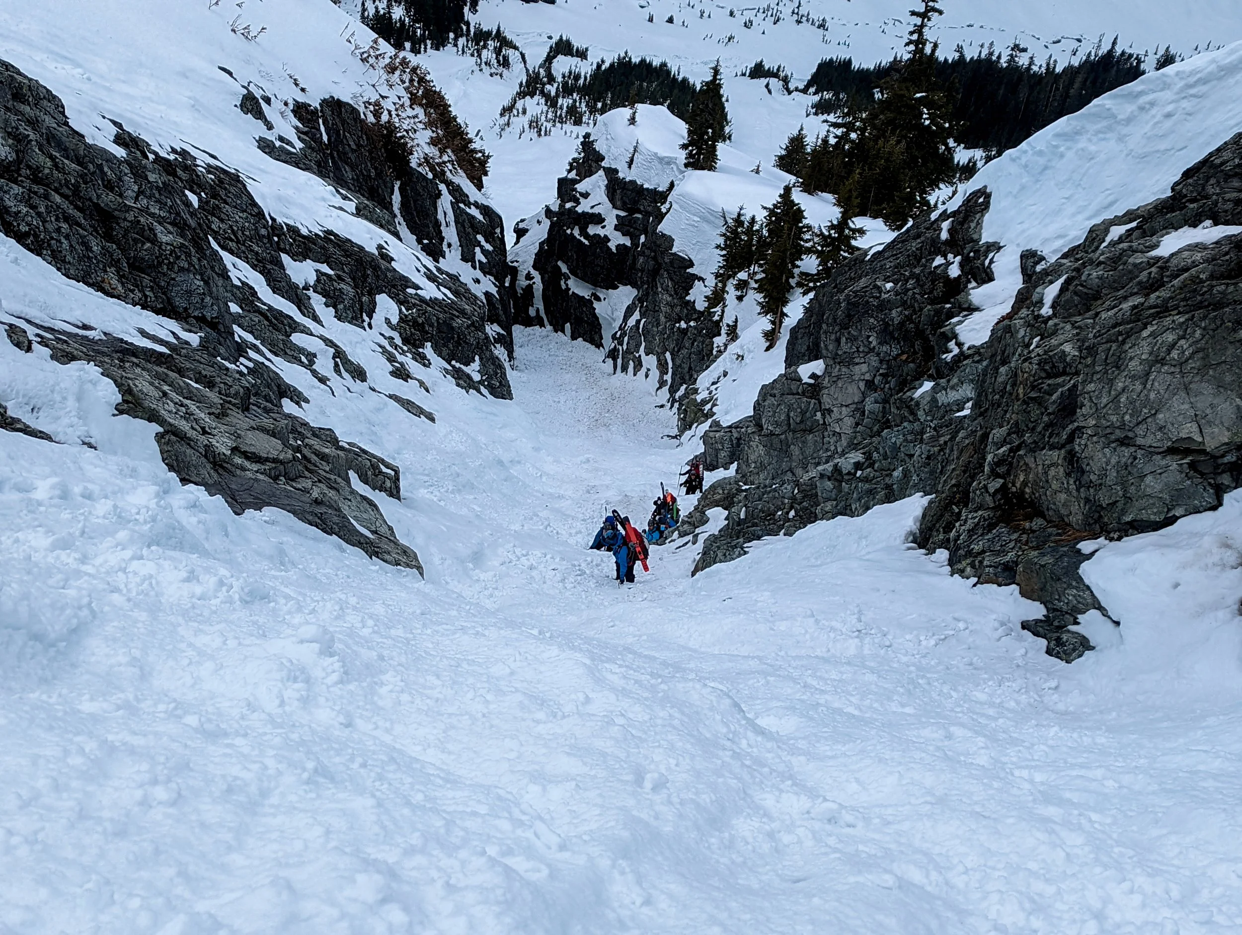
The Imperfect Impasse. We entered from the right, near where the last person is in the photo. This saved us from having to drop down even further
We roped up, and crossed the Challenger Glacier in three teams of three. Not being able to see much, we followed the map and generally contoured around. Eventually, the clouds parted, and we were greeted to blue skies and spectacular views up towards Mt. Challenger and to the Chiliwack’s in the North. Making our way further, Luna became visible, and we reached a nice flat spot on the far side of the Challenger Glacier for a break, and to dry out wet gear in the afternoon sun.
This would have been a fine place to camp, but with rain in the forecast for tomorrow, we were a little anxious about getting down the slopes below us and back into tree line. With the abundance of wet loose, wet slab, and cornice fall we had witnessed over the past few days, we didn’t want to wait for the snow to get even more saturated. With a good amount of daylight still left, our lead rope team went ahead to scout out the way down while the others dried gear and ate some food.
We skinned up out of the dip we were in, and very soon were greeted with the most spectacular view of the Pickets in all its glory. The North face of Mt. Fury towering in front of us, with a jagged, picket fence ridgeline leading to Mt. Challenger. This was a breakthrough moment for me, and I can say it changed my perception of the outdoors, and of the mountains. After not seeing a sign of another person for four days, in a range I didn’t even know existed, in the state I grew up in, it really showed that despite by complaints of crowds and traffic, there is still remoteness out there.
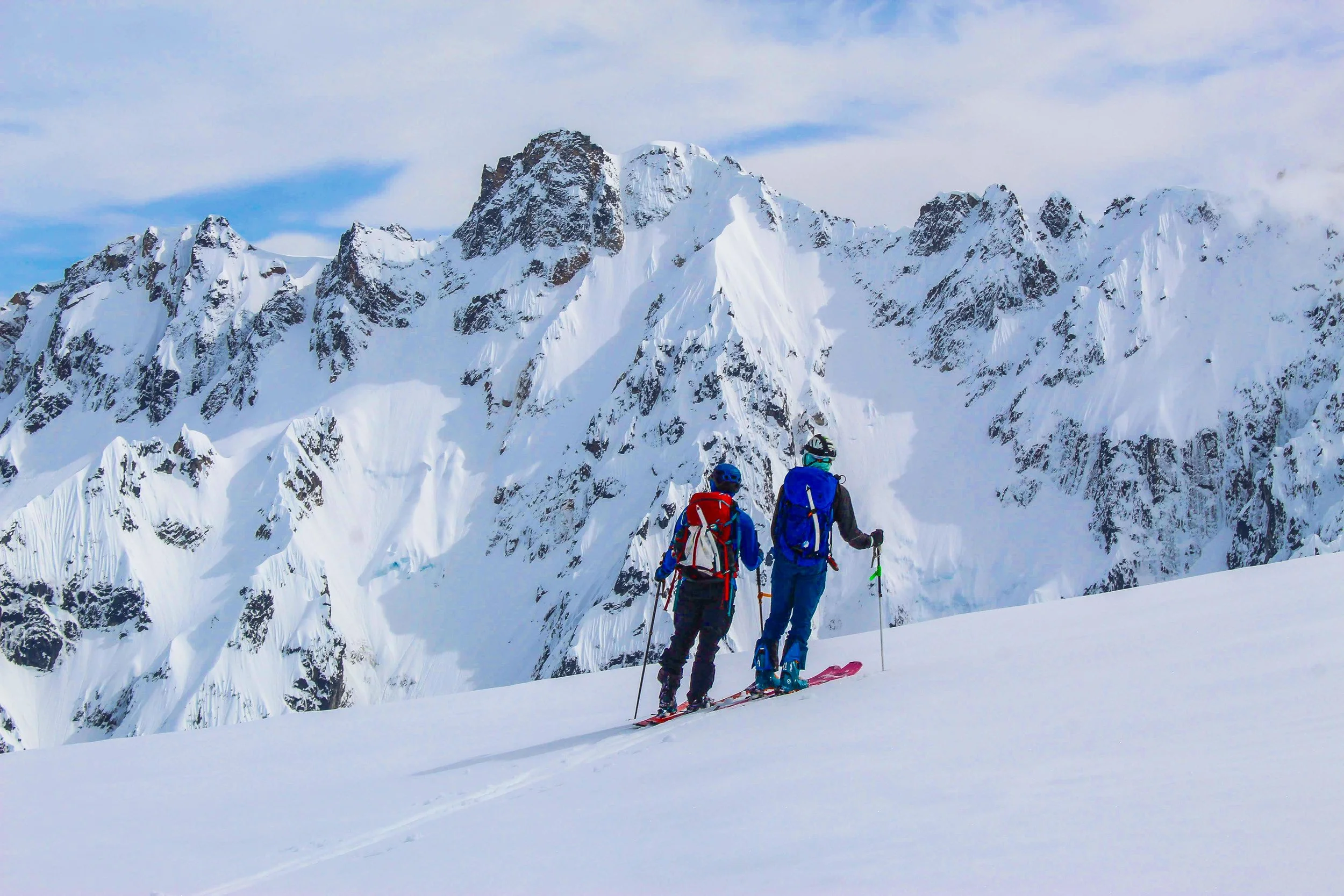
Taking in the views. The North Face of Mt. Fury looking like it was dropped in from Alaska
We located a potential path down, grabbed the rest of the group, and started out. It started as a pretty good descent. The snow was a little slushy, but the slope was moderate and we hadn’t seen any natural slides since we started across the Challenger Glacier. Visibility was good, so we spread out as we made our way down the cirque, aiming for Luna Creek. With the day getting later, we started to feel a little more rushed. Dropping lower, the terrain started getting a little more complex.
The three of us in the lead skied ahead a bit to find the way, focusing our attention to route finding and away from the fact that the snow was becoming more and more saturated with every foot we descended. Finally, the leader hit a small rollover, and a crack spread out to the steep slope in front of him, releasing a slab that gained traction until it disappeared off a cliff below. Realizing now the seriousness of the terrain we had entered, we came to the conclusion that we couldn’t get down this way. Too many terrain traps and prime 38 degree slopes were ahead. We backtracked upwards and out of the steeper terrain to the rest of the group, and started looking for the best way to get out. With night approaching, we decided we would wait till early morning, hopeful the snow would refreeze some. If we went down further north in the cirque, where it was more forested, lower angle, and contained less terrain traps, we would minimize the exposure to avalanche terrain and hazards. Backtracking enough to find a sheltered area, we dug in for a bivy, ready for an early start, and with better understanding of the state of the snowpack.

Turning back - the terrain ahead was wet slab central, all above rocky cliffs. When traveling in large groups, have a small element scout ahead, that way the whole group isn’t committed in consequential terrain before it’s too late. Notice how wet the snow is, something we should have been more aware of, as well as the debris fans beyond.
Day 5:
We woke up bright and early, the sound of rain pattering on the shelter walls. We got going, carefully navigating our route to minimize exposure to avalanche terrain. Making our way around the cirque to what looked like the best path down, we started booting, making sure to minimize the chance of someone above setting something off.

In “safer” terrain. Notice all the debris, and our path, in the open slopes behind, as well as the path we just crossed.
Once in the trees, things became more manageable. The snow was still wet, and we started purposely triggering wet loose slides that built up and cleared out a line down. This movement was slow and methodical, because at this point the safety of the group was the biggest concern, and the avalanche hazard was our biggest threat. After several hours of being on edge, the ground flattened out, and we had made it to the bottom, out of any avalanche terrain. It was a sigh of relief. Between the leadership of the more experienced and the calm and coolness of the rest, we were able to safely get down.
Making our way along Luna Creek towards Big Beaver Creek, we could start to hear the crash of natural avalanches up high. After a few miles, the day was getting late and we made camp. I think we all slept much better that night.

One of several avalanches coming down off of Luna Peak
Day 6
Out of the technical terrain, it was just mileage here on out. But if you’re familiar at all with Cascade Traverses, you know that the exits are never that easy. This one would be no different. After a few small crossings and a nice big log scoot, we reached Big Beaver Creek and the trail that follows it. Not long after, we actually had snow free trail! With a visible trail and no snow, estimates that the walk back towards Big Beaver Campground would only take a few hours were thrown out. But because it’s the Cascade’s, it’s never that easy.
Very quickly it turned back into snow. We skinned for a while, but at this point, everyone’s skins were so saturated that multiple ski straps were attached to each one, the sticky glue all but worthless. Then the downed trees started. With the weather the past year, and a shortage of trail crews from the past few summers because of covid, the blowdowns were relentless. Eventually we gave up on skinning as we had to get over log after log. Post holing, falling off of logs, and skis getting caught on everything made for a horrendous time. But we kept moving, getting closer and closer to the campground. After breaking out headlamps, the next thing we knew we were at the campground. A few members from our unit had come out to meet us, ready to hear the tales of the trip. They told us it would be a clear night, so as exhausted as we were, we just spread out our sleeping bags on the ground and passed out.

Making our way into Big Beaver Campground

Waking up after our “clear” night.
Day 7
Knowing we were nearly done, waking up to the rain and wet sleeping bags didn’t even phase us. No more skinning, no more downed trees, just a trail and a dam and we would be back at the cars. Seeing people for the first time after we had stepped off a week before, the smell of cleanliness hit our noses, and made us come to terms with the stench we were putting out. 7 days of snacks, GU’s, freeze-dried meals, and soaked clothing gave off a stench that would make a pig nauseous.
The trail out was actually quite pleasant. Views of Ross Lake greeted us, and looking out at the alpine peaks off in the distance gave perspective to how far we had traveled. After crossing the dam, a short uphill brought us to our cars, and the end of the journey.

Walking the last mile across Ross Lake Dam
Key Takeaways
-This was one of, if not the most, difficult thing I had done in the military. I am extremely proud of what we pulled off. With a high turnover rate and members constantly rotating in and out of the team, it’s difficult to build up enough longevity and skill to tackle harder and technical terrain. The fact that we pulled off the traverse with a group that big, let alone that some members had been on skis for barely a year, showed that when empowered to train and plan properly, you can accomplish a lot.
-A big part of this trip was to see how hard we could go with how little. Once you start adding on military equipment, you need to have as light of a base pack as possible. This feeds into the big three of moving in the mountains - expereince, skill/ability, and gear. The more technical terrain you get into, the more of all three of those you need. For a certain technical objective, the more experience and skill you have, typically the less gear you need, because you know how to do more with less. The less experience and skill, the more gear you’ll take to have the same safety margin. But gear can only get you so far, and can not overcome deficiencies in skill and experience - things that only come with proper training and preparation.
-Adding on to the skills/experience, those of us up front coming down from the Challenger Glacier came away with a much better understanding of spring snow conditions. As we were descending, the snow had became way too wet. Stepping into it without skis, we sank down over our boots, a clear sign that wet slabs were a strong possibility. Since then, there has been several times I’ve seen the snowpack start to get too saturated and scaled back on the plans for the day. You have to learn from mistakes in the mountains, and you will make mistakes, but it’s crucial that you don’t leap to far too fast.
-Overall stats were somewhere in the ballpark of 41 miles and 15,000’+ elevation gain(map stats, with all the switchbacks and backtracks, real stats were more). I would love to come back and do the full traverse one day.


